WWII History of US Navy Rubber Life Raft Charts |
||||||||||||||||||||||||||||||||||||||||||||
|
Table of Contents
Before the production of the AAF and NACI-HO rayon acetate maps and charts began, the US Navy produced US Navy Hydrographic Office Pilot Charts on oil cloth of the Atlantic and Pacific Oceans for use in the navigation of lifeboats and rafts by survivors of torpedoed ships. These charts were copies of the standard Hydrographic Office paper Pilot Charts discussed below.[1]
The idea of placing Pilot Charts prepared by the US Navy Hydrographic Office in US lifeboats appears to have originated with Dutch Master Mariner J.G. Bruin, prior to the US's entrance into WWII. The July 1941 issue of the British publication Nautical Mariner contained a letter written to the editor by Captain Bruin regarding his experience as a passenger on a British ship and recommending that Pilot Charts be placed in lifeboats stored on all British ships. He related that while on board he inquired what nautical charts, if any, the lifeboats contained. The response from one of the crew members was that the lifeboats didn't contain any, although considered necessary it had been like this for ages, and that it would probably take at least a hundred years before they received charts. Apparently, this exchange spurred the Dutch captain to appeal directly to British shipowners on behalf of their crews. Captain Bruin recommended that British shipowners supply their crews for this purpose the pilot charts prepared by the US Navy Hydrographic Office. He explained the utility of the pilot charts relating the following example: [N]ear Freetown on the African coast, where recently a number of crews had to take to their boats, in latitude 5° North and longitude 15° West one has to steer North or N.N.E. to reach the shore near Freetown. A boat steering true East (the shortest distance as the crow flies) will never get to the shore but driven along the coast into the open by the strong Equatorial Current setting along the coast. Many more useful things are to be taken from the charts and all Dutch ships are carrying them in their lifeboats so why not the British?[2]
The US Secretary of the Navy forwarded a copy of the Nautical Mariner letter to the Chairman of the US Maritime Commission for the commission�s consideration on US ships and offered the assistance of the US Navy Hydrographic Office if the suggestion was adopted.[3] On August 29, 1941, the Chairman of the Maritime Commission responded that the commission had approved the suggestion and intended to equip every lifeboat carried on American merchant vessels operating in dangerous sea zones with a copy of the Hydrographic Office Pilot Charts of the area involved.[4] Shortly thereafter, a meeting was held at the Hydrographic Office and it was agreed that the office would supply the Maritime Commission with 300 copies each of the Pilot Charts of the North Atlantic Ocean for November, the South Atlantic Ocean for summer, and the Indian Ocean for December without charge by the middle of October 1941, with each chart bearing the stamp For Use In Lifeboats Only.[5] In January 1942, after the US entrance into WWII, the US Coast Guard's Bureau of Marine Inspection and Navigation amended its General Rules and Regulations mandating for the duration of the Emergency that every vessel whose route at any point lies more than 200 miles offshore carry a current Hydrographic Office Pilot Chart of the waters navigated. The regulations required that the charts be stowed in a metal container in each lifeboat to keep the charts dry. The Bureau interpreted this requirement as mandating an appropriate seasonal Pilot Chart depicting ocean currents and surface winds to be expected, but did not require the charts be changed monthly, even though the Hydrographic Office published charts for each month. The Maritime Commission's policy was to place a summer or winter chart in each lifeboat as necessary.[6] In November 1943, the Coast Guard asked the Hydrographic Office if it could print the lifeboat Pilot Charts for merchant vessels on the same cloth that the Army Air Force was using for its cloth escape maps.[7] The Hydrographic Office stated this was feasible and suggested that the Coast Guard or Maritime Commission should enter into its own contract with William Kuhlman & Company if it desired to pursue this.[8] This does not appear to have occurred because in December 1943 the Hydrographic designed five special paper Pilot Charts of the North Atlantic, South Atlantic, North Pacific, South Pacific, and Indian Ocean, one side of each chart was for the summer months and the other side for the winter months. This eliminated the need for the periodic replacement of the charts and allowed for them to be permanently placed in metal containers in lifeboats.[9] In January 1944, the Hydrographic Office began selling these charts at 5 cents per chart to lifeboat manufactures for installation in their lifeboats.[10]
In late 1942, the US Navy Hydrographic Office began exploring with the William Kuhlman and Company of Allentown, Pennsylvania, the possibility of printing Pilot Charts on oil cloth to be carried on lifeboats aboard US Navy ships.[11] In correspondence to the Chief of the Bureau of Aeronautics in November 1942, the Navy Hydrographer sought approval to begin producing the oil cloth Pilot Charts, describing their usefulness as follows. Research for a suitable material led to the enclosed impregnated fabric which appears to be ideal for the purpose. It is water-proof, non-crushable, unaffected by salt water and sunlight, folds compactly and may be quickly smoothed out for use....This chart should also prove valuable as a means of catching rain water, as an auxiliary sail, as a covering to protect the body from the sun, rain, and spray. Further, with the land areas printed in bright yellow ink, it would serve as a signal to searching ships and planes.[12]
[It is interesting to note that material used for the charts was described as non-crushable, and probably was when new; however, the material has not withstood the test of time. Anyone lucky enough to get possession of a pack of these charts today will quickly learn that unfolding the charts can be difficult as the charts are quite brittle, especially along the fold seams, and will deteriorate fairly quickly if soaked in water. This is in contrast to the AAF rayon acetate cloth maps, which can be readily found in like new condition today.] Shortly thereafter, the Bureau of Aeronautics approved production and the Navy Hydrographic Office began negotiating a contract with William Kuhlman and Company.[13] In January 1943, the Navy decided that the Bureau of Aeronautics would award the contract instead of the Hydrographic Office[14] which was done later that month. The contract was for the printing and packing of 150,000 packages, each consisting of the following charts:
The total price of the contract was $516,750.00, with each two-sided chart costing 85 cents and an additional 45 cents allotted for packing and the packaging material of each four chart package. Thus, each package of charts cost $3.85. The contract states that the William Kuhlman and Company, was a legal partnership between Misters William Kuhlman and E.N. Reinsel. The contract required the delivery of 25,000 packages within 90 days, with another 25,000 packages delivered each 30 days thereafter. The contract specification provided that the charts would be 26 inches by 38 inches and stated:
Item 1. Each of the water-proof life raft charts for installation in the pneumatic life rafts are to be printed by the contractor from positypes furnished by the Government on each side in the following three colors: the land areas in yellow, the base in black, and the remainder of the chart in blue. Each chart is to be made of water-proof noncrushable material which will be affected by neither salt water nor sunlight. Both sides of the material are to be coated to a sufficient opaqueness so that the printing on one side of the chart will not show through on the other side. The area shown on one side of the chart will be for the summer season, and the area shown on the reverse side will be for the winter season.
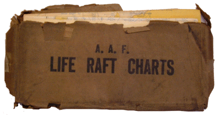
Item 2. The four charts showing the various areas listed in ...Section 1 shall be folded in a packet nine (9) inches long by four and one-half, (4 1/2) inches wide and one-fourth (1/4) inch thick, in order that it may be stored in the supply pocket of pneumatic life rafts. This packet is to be wrapped in a suitably oiled paper water-proof container held firmly in shape by water-proofed, gummed strips. Both of the large sides of the outside of the container shall be plainly marked in a water-proof ink "Life Raft Charts". The weight of each package wrapped in the container shall not exceed on and one-eighth (1-1/8) pounds.
One hundred packets were packed in each shipping crate. The contractor was advanced $125,000.00.[15] Because of delays in obtaining raw materials, the contractor did not begin deliveries of the Pilot Charts until July 1943.[16] Also, in January 1943, the US Navy Hydrographic Office informed the AAF that the Navy intended to produce oil cloth Pilot Charts.[17] Immediately upon receiving the letter, Headquarters, AAF directed the Aeronautical Chart Division to take the necessary action to obtain these waterproof charts for installation in life rafts carried on AAF planes and to work out a procedure with the AAF Material Command for the installation of the charts in life rafts. It was suggested that in addition to the individual charts a chart of the world also be printed on the sail or covering of the life raft. In this way, regardless of the destination or area in which the life raft ended up, there would always be a waterproof map aboard.[18] In March 1943, the Aeronautical Chart Division dismissed the suggestion because (1) sails were not included with all airplane life rafts, (2) the size of the sails was beyond the capability of current printing presses, and (3) it was impractical to print the charts on the paulin because the colors adopted for camouflage will not receive the colors used in the chart.[19] The paulin cloth was vinyl treated for waterproofing and was dark blue on one side and orange yellow on the other. The purpose of the paulin was to catch water, for use as a covering, and for camouflage. The dark blue side when turned up simulated the surrounding blue water, while the orange-yellow side turned up served to attract attention from would be rescuers.[20] As an aside, the Hydrographic Office also considered the idea of printing Pilot Charts on cloth sails, rejecting the idea as unfeasible because sails were too large for off-set printing and too small to contain all of the data on the four Pilot Charts.[21] Although the Aeronautical Chart Division considered cloth charts similar to the existing AAF Road Map of West Africa, it was decided that the Navy Pilot Charts were preferable because of the extensive navigation data they contained. After staffing the idea among various branches of HQ AAF for almost one year, with differing staff recommendations,[22] the Army Air Forces Board finally decided on the recommendation of the Aeronautical Chart Division to procure for use on AAF lifeboats, the four Navy Pilot Charts and added an additional chart of the Indian Ocean[23] that was provided to the William Kuhlman and Company in January 1944 by the Navy Hydrographic Office.[24] The Indian Ocean Pilot Chart had not been included in the Navy contract because the area was zoned as a British theater of war; however, was included by the AAF because of the widespread activities of the Air Forces, particularly, the Air Transport Command.[25] The approximate cost for 100,000 five-chart packages was $470,000.[26] The Army Air Forces Board considered this a temporary expedient pending development and procurement of more suitable charts.[27] Perhaps the ACS request of July 1945 for AMS to prepare cloth charts C-62 (Pacific Ocean) and C-63 (Atlantic Ocean) were intended to replace the Navy Pilot Charts, although the charts were compiled they were never printed because of the war ended before they could be printed.[28] AAF aircrews probably didn't need all of the navigation information drawn on the Navy Pilot Charts because use of all the information probably necessitated the skill of a nautical navigator not normally possessed by airplane pilots.
AAF Oil Cloth Lift Raft Charts Packet
The five-chart rubber life raft Pilot charts consisted of:
AMS procured a total of 139,000 five-chart packages, with the orders in March 1944 (78,000 packages), July 1944 (26,000 packages), September 1944 (21,000 packages), and February 1945 (34,000 packages) placed with the William Kuhlman and Company to satisfy both AAF and subsequent Navy requirements.[29] Like the four-chart packs, the color of land on the charts for AAF is bright yellow, with water a faded yellow, base features in black, and nautical information in blue. The trim size of the charts is approximately 37" x 25".
[1] See "Cloth Charts Bring Survivors Back", Air Sea Rescue Bulletin, Vol. II, No. 1, September 1945, pp. 2-7.
[2] Letter to the Editor, Nautical Magazine, edition July 1941, from Master Mariner J.G. Bruin, attached to letter to Chairman, US Maritime Commission, from Frank Knox, Secretary of the Navy, August 21, 1941.
[3] Letter to Chairman, US Maritime Commission, from Frank Knox, Secretary of the Navy, August 21, 1941.
[4] Letter to Honorable Frank Knox, Secretary of the Navy, from Chairman E.S. Land, Maritime Commission, August 29, 1941.
[5] Letter to Captain G.S. Bryan, US Navy Hydrographer, from G.H. Helmbold, Director, Operations and Traffic, US Maritime Commission, October 30, 1941.
[6] Memorandum to Officers-in-Charge, All Branch Hydrographic Offices, from G.S. Bryan, US Navy Hydrographer, January 21, 1942, Subject: Pilot Charts to be Placed in Lifeboats.
[7] Memorandum to US Navy Hydrographic Office from Chas. A. Parks (by direction), US Coast Guard, November 9, 1943, Subject: Hydrographic Office Pilot Charts For Use In Lifeboats And Life Rafts On Merchant Vessels.
[8] Internal US Navy Hydrographic Office memo slip attached to Memorandum to US Navy Hydrographic Office from Chas. A. Parks (by direction), US Coast Guard, November 9, 1943, Subject: Hydrographic Office Pilot Charts For Use In Lifeboats And Life Rafts On Merchant Vessels.
[9] Memorandum to All Branch Hydrographic Offices from G.S. Bryan, US Navy Hydrographer, December 27, 19943, Subject: Pilot Charts for Lifeboats.
[10] Letter to Globe American Corporation from J.D. Yates, Chief, Finance & Sales, US Navy Hydrographic Office, January 28, 1944.
[11] Letter to William Kuhlman and Company, Allentown, Pennsylvania, from Rear Admiral G.S. Bryan, US Navy Hydrographer, October 13, 1942.
[12] Memorandum to the Chief of the Bureau of Aeronautics from the US Navy Hydrographer, November 11, 1942, Subject: Water proof charts for rubber rafts.
[13] Letter to William Kuhlman and Company, Allentown, Pennsylvania, from Rear Admiral (Ret.) G.S. Bryan, US Navy Hydrographer, December 10, 1942.
[14] Memorandum to Chief of the Bureau of Supplies and Accounts and the Hydrographer, from Captain E.A. Cobey, Bureau of Aeronautics, Navy Department, January 14, 1943, Subject: Purchase of Waterproof life raft charts.
[15] US Navy Bureau of Aeronautics Contract No. NOa(s) 222 between the United States of America and William Kuhlman and Company. January 1943.
[16] Memorandum to Office of the Vice Chief of Naval Operations from Major M.G. Haines (USMC), Navy Bureau of Aeronautics, June 9, 1943, Subject: Charts for Use with Pneumatic Life Rafts – Availability of.
[17] Memorandum for Colonel Murray B. Crandall, US Army, form Commander (retired) G.A. Patterson, Officer-in-Charge, Director of Research, US Navy Hydrographic Office, January 5, 1943, Subject: Waterproof charts for use in Rubber Life Rafts.
[18] Memorandum to Director of Photography, Aeronautical Chart Division, HQ AAF, from Brig. General L.P. Whitten, Director of Base Services, HQ AAF, January 11, 1943, Subject: Waterproof Charts for Use in Rubber Life Rafts.
[19] Memorandum to Director of Base Services, HQ AAF, from Colonel Minton W. Kaye, Photography, Aeronautical Chart Division, March 3, 1943, Subject: Waterproof charts for use in Rubber Life Rafts.
[20] Memorandum to Major A.G. Foote, Chief, Production Section, from L.A. Bloom, Cartographic Engineer, Production Section, January 29, 1943, Subject: Waterproof Charts for Use in Rubber Life Rafts.
[21] Memorandum to Chief of the Bureau of Aeronautics, US Navy, from G.A. Patterson(by direction of the Hydrographer), September 2, 1943, Subject: Imprinting of Maps and Charts on Life Raft Sails.
[22] Memorandum to Director of Base Services, HQ AAF, from Colonel Minton W. Kaye, Photography, Aeronautical Chart Division, March 3, 1943, Subject: Waterproof charts for use in Rubber Life Rafts, with Comments 1-13, Comment 13 dated December 23, 1943.
[23] Memorandum to Executive Officer, Army Air Force Board, from Brigadier General H.A. Craig, Assistant Chief of Air Staff, Operations, Commitments & Requirements, January 13, 1944, Subject: Waterproof Charts for Use in Life Rafts; ACS Weekly Report (13 Sept 43 – 18 Sept 43) from Capt. L.C. Benedict (ACS) to Historical Officer, September 20, 1943; Memorandum to Director of Base Services, HQ AAF, from Colonel Minton W. Kaye, Photography, Aeronautical Chart Division, March 3, 1943, Subject: Waterproof charts for use in Rubber Life Rafts.
[24] Letter to the Navy Hydrographic Office from William Kuhlman, William Kuhlman & Co., January 31, 1944.
[25] Memorandum to Major A.G. Foote, Chief, Production Section, from L.A. Bloom, Cartographic Engineer, Production Section, January 29, 1943, Subject: Waterproof Charts for Use in Rubber Life Rafts.
[26] Memorandum to Director of Base Services, HQ AAF, from Colonel Minton W. Kaye, Photography, Aeronautical Chart Division, March 3, 1943, Subject: Waterproof charts for use in Rubber Life Rafts.
[27] Memorandum to Executive Officer, Army Air Force Board, from Brigadier General H.A. Craig, Assistant Chief of Air Staff, Operations, Commitments & Requirements, January 13, 1944, Subject: Waterproof Charts for Use in Life Rafts.
[28] AMS Production Order No. 3-6851 (1945).
[29] AMS Production Order No. 30559 (1944); AMS Production Order No. 32248 (1944); AMS Production Order No. 3-3026 (1944); AMS Production Order No. 3-2876 (1944); AMS Production Order No. 3-5099 (1945). |
||||||||||||||||||||||||||||||||||||||||||||
|
|
||||||||||||||||||||||||||||||||||||||||||||
|
© Copyright 2008. All rights reserved. |
||||||||||||||||||||||||||||||||||||||||||||