|
History of WWII US Cloth Escape Maps |
||||||||||||||||||||||||||||||||||||||||||||||||||||||||||||||||||||||||||||||||||||||||||||||||||||||||||||||||||||||||||||||||||||||||||||||||||||||||||||||||||||||||||||||||||||||||||||||||||||||||||||||||||||||||||||||||||||||||||||||||||||||||||
|
Table of Contents A. The Army Map Service Road Map of West Africa B. The Army Map Service Finds a Suitable Fabric C. The Army Map Service Investigates the Practicability of D. The Army Map Service Begins Mass Production of Cloth Maps 1. Southwest Pacific Area Series 6. Miscellaneous AAF Escape Maps F. Navy NACI-HO Survival Cloth Charts G. RAAF Silk Escape Maps Produced for MIS-X
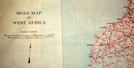
A. The Army Map Service Road Map of West Africa The United States' first venture in the production of cloth escape maps during World War II began in the later part of October 1942 in response to an Army Air Force (AAF) request for the Army Map Service (AMS) to produce 2,000 cloth maps of West Africa at a scale of 1:5,000,000. The cloth map, known as the Road Map of West Africa, was printed in three colors and had to be delivered in less than one week.[46] There was no complete paper map sheet of this entire area so the cloth map was complied from three different automobile tourist road maps of different scales published by Michelin, which resulted in the need to print three different map legends, one for each respective map section. The map contains the normal tourist information with locations of hotels, gas stations, telegraph, telephone and postal facilities. The maps even depict camel trails and indicate the time required to travel by camel between different points.
Road Map of West Africa Because time was of the essence, the Army Map Service printed the maps on mounted balloon cloth draw from existing Army Map Service stock that had been prepared fifteen years earlier for a series of Panama maps. (Click here to view the four Panama maps.) Because balloon cloth, which cost approximately 50 cents a square yard,[47] was a thick and bulky material made of tightly woven Egyptian cotton and frayed easily, it was not an ideal material for escape maps, but the maps were produced on time. [48] A week later another run of 500 maps was printed at the request of AAF.[49] B. The Army Map Service Finds a Suitable Fabric In early 1943, the AAF unofficially informed the Army Map Service that AAF would require 75 to 100 different escape and evasion cloth maps in editions of 2,000 each within the year. The Army Map Service canvassed the commercial lithographic industry and decided that the Kaumagraph Company of Wilmington, Delaware, was best suited to research the problem due to its long and varied experience with lithography on cloth and its close proximity to both the DuPont Corporation and Washington, DC, where the Army Map Service was located. In early March 1943, Mr. Thomas H. Miller, Vice President and Treasury of Kaumagraph, was given a sample of a British RAF viscose rayon map and was requested to furnish printed samples on a similar fabric.[50] On March 10, 1943, Kaumagraph called the Army Map Service suggesting that acetate rayon with a 100 denier, 110 count might be a suitable material for printing the cloth maps.[51] Acetate rayon was selected over viscous rayon because viscous rayon contains moisture and has a tendency to mildew, while acetate rayon is a dry yarn and is not so affected. Furthermore, although both fibers are made from wood pulp, because viscous rayon is highly water adsorbent it stretches and shrinks easily when wetted, while acetate rayon does not. Also, acetate rayon is plasticized when heated. After conducting considerable research and consulting with the DuPont Corporation and Burlington Mills, Kaumagraph submitted four samples of acetate rayon cloth manufactured by Burlington Mills: a taffeta weave calendered and uncalendered, and a twill weave calendered and uncalendered. [52] On April 22nd Kaumagraph submitted two more samples with sealed edges of the taffeta calendered cloth with a thread count of 92 by 68, with a two color road map of metropolitan New Jersey printed on both sides.[53] (Click here to see the sample map.) At the same time, the Army Map Service had also been in contact with the Celanese Corporation of America located in New York City, a manufacturer of rayon yarns. On April 15, 1943, Celanese representatives met with Army Map Service officials and provided three samples of acetate rayon fabric for consideration. The samples were: taffeta 3.5 oz per sq ft; taffeta 3 oz per sq ft; and satin 5.8 oz per sq ft. During the meeting with Celanese, the Army Map Service determined that all of these samples were too heavy and thus Celanese did not leave the samples with the Army Map Service for further consideration. Instead, Celanese suggested Fortisan, a high tenacity yarn produced by Celanese.[54] However, on April 19, 1943, Celanese sent a letter to the Army Map Service stating that upon further reflection Celanese believed Fortisan was too critical a wartime material for cloth map production so Celanese did not want to commit to a map printing program using Fortisan and then have the material taken away by other military services for AA-1 or AAA higher priority wartime programs.[55] On May 6th Celanese submitted two samples of dull taffeta acetate fabric designed for map printing. The 20 yard fabric rolls were identified as: (1) 2.9 oz per sq yd, 120 denier in both warp and filling and a thread count of 88 by 80 and (2) 2.8 oz per sq yd, 120 denier in warp and 150 denier in the filling with a thread count of 86 by 66.[56] On May 7th, the Army Map Service sent the fabric rolls submitted by Celanese to Kaumagraph and requested that Kaumagraph print some samples on both sides of the cloth so the Army Map Service could test the materials' suitability for cloth maps.[57] On May 14th Kaumagraph acknowledged receipt of the rolls, remarking that the materials were similar if not identical to the samples that Kaumagraph had previously submitted to the Army Map Service.[58] In the meantime, the Army Map Service had sent the four samples of twill and taffeta rayon submitted by Kaumapgraph to the National Bureau of Standards of the United States Department of Commerce for testing. The April 15th report from the National Bureau of Standards states: The printed images on the maps were found to be extremely fast to the action of light. No appreciable effect was noted after 100 hours exposure in the Fadeometer. The printed material showed good resistance to salt water. Specimens, to which were sewed pieces of unsized cloth, showed neither change in color not bleeding when immersed for one hour in a solution containing three percent sodium chloride, one-half percent magnesium chloride, and one percent salt water soap. Specimens were exposed to the action of Chaetomium globosum under standard conditions for seven days. At the end of this period, the specimens showed every slight or no growth of mildew, indicating good resistance. Ordinary untreated cotton osnaburg generally shows a rather heavy growth of mildew under the same conditions. There were no differences noted among the four submitted samples in any of the tests.[59] As an aside, there is little anecdotal evidence of how the rayon maps actually held up during field use. However, MIS-X units in China and SWPA reported problems with blood chits printed on rayon acetate. These units noticed that the ink on the blood chits faded during use. In July 1945, HQ MIS-X took up the matter with the commercial printer of the chits. It was learned that rayon acetate fibers are smooth and hard like glass rods and thus they do not allow ink to adhere well and or penetrate the fibers. The printer experimented with other inks and changed to an ink which it believed offered more permanency. No similar problems, however, were reported regarding rayon maps. This is probably due to the fact that bloodchits were often sown into the inside lining of flight jackets thus undergoing excessive abrasion during normal wear and were laundered, while cloth maps were not subjected to such wear.[60] On April 22nd the Army Map Service sent one of the calendered metropolitan New Jersey map samples supplied by Kaumagraph to Fuchs & Lang Manufacturing Company, a Division of General Printing Ink Corporation, of New York City to conduct weathering and salt water tests.[61] On April 30, 1943, Fuch & Lang responded in writing that the maps had been subjected to 65 hours in the Weatherometer, which was equivalent to 32 days, and 6 hours to the salt water test without any injurious effect in either case.[62] On May 21st the Army Map Service selected the plain calendered dull acetate taffeta as the best cloth, noting that it was a standard fabric and could be made from either DuPont or Celanese yarns by any mill capable of weaving rayon. The Army Map Service report also pointed out that Celanese Corporation not only manufactured yarns which were sold to various cloth mills, but also had its own weaving facilities.[63] The suggested specification for the cloth maps submitted by Kaumagraph and adopted by the Army Map Service is as follows: SPECIFICATIONS FOR ACETATE RAYON FABRIC FOR MAP HANDKERCHIEFS Width: Minimum 42" Maximum 43" Count: Warp -- Minimum -- 92 Filling -- Minimum -- 58 Weight: 2.50 ounces per square yard - maximum Tensil Strength: (Grab System) Warp: 25 lbs. Minimum Filling: 20 " " Elongation: Warp: 10% Filing: 15% Tensil Strength (Trapezoid) Warp: 3.0 lbs " Filing: 3.0 lbs. " Porosity: 10 - Maximum Thickness: 36/10.000 - Maximum Residual Skrinkage: Warp -- 2% - Maximum Filing -- 3% - Maximum Finish: Flat, smooth surface, approximately an egg shell texture, on both sides of fabric. All tests according to Spec. CCC-T-191A. Length of pieces and rolls and allowances for imperfections in accordance with Spec. AN-CC-S-371. AN-CCC-S-371 NOVEMBER 21, 1939 ARMY-NAVY AERONAUTICAL SPECIFICATION SILK: PARACHUTE E-10. Allowance. The total yardage supplied under any contract or order shall include an allowance of not less than 1/2 yard for each tagged defect included. For a continuous defect extending over a length more than 1/2 yard, such as a broken warp end or float, the length of allowance material to be furnished shall be equal to the length of the defect.[64] The Army Map Service report describes the printing process for cloth maps as follows: The ordinary lithographic processes and equipment are utilized in printing on cloth, but due to the lack of body the material is mounted on paper. Most cloth is printed on one side and is attached to the paper with a fairly heavy paste. In order to reduce the size, the Army Air Force cloth maps will be printed on both sides. If the cloth is pasted, the back is coated with paste and the ink prints on this layer instead of the cloth. If the map becomes wet the paste dissolves and the printed image washes off. A film of wax was tried as an adhesive; this held the cloth satisfactorily and allowed it to be easily stripped, but the wax coated the cloth so that the ink would not adhere. Finally, Mr. Miller located a DuPont product that had the proper adhesive qualities with none of the disadvantages of either paste or wax.[65] After the back was printed, the map was stripped, cut, edged, sealed, folded, and packed. The May 21st the Army Map Service report notes that the edges of the British cloth maps were either hemmed or a white pigment-like substance was applied around the border. This produced a stiff quarter inch band that caused wrinkles when the maps were folded. The Kaumagraph Corporation, however, overcame this condition by developing a solvent that partially dissolved the acetate fibers and fused them so the edges would not fray.[66] The Kaumagraph Corporation had no interest in furnishing the rayon cloth and stated Kaumagraph could lithograph on any material furnished by the Army Map Service. In May 1943 the acetate rayon cost manufactured by Burlington was quoted to the Army Map Service as 25 1/2 cents per running yard in 42 inch widths. Celanese did not quote a firm price, but their Washington representative told the Army Map Service the price would be within two or three cents of Burlington's price of 25 1/2 cents. Regarding the estimated costs of lithography, Kaumagraph quoted the following prices for producing 2,000 cloth maps in four colors, both sides, edges sealed, folded to handkerchiefs size and packed in bundles of 50. The prices assumed the Army Map Service would furnish the cloth and the complete blueline map sheet boards. The estimates were for two different sizes of maps--either of which could be cut economically from the 42 inch widths cloth rolls: 16 1/2" x 19 3/4" and 19 1/2" x 19 1/2". For the 16 1/2" x 19 3/4" maps, the cost was 26 cents each and if two different maps were run at the same time the cost would be 24 1/2 cents each. The 19 1/2" x 19 1/2" size would cost 30 cents, if two maps were produced at the same time the cost would be 30 cents, and if four maps were produced simultaneously the cost would be 18 2/10 cents.[67] In view of the shortness of the runs, complexity of the printing process, and amount of the hand work involved, the Army Map Service deemed it impractical to produce the cloth maps at the Army Map Service base printing plant in Washington, DC. Accordingly, the Army Map Service report recommended the printing of the maps be contracted out to commercial printers.[68] [It is worth mentioning that near the end of the war from approximately February 1945 until July 1945, the Army Map Service was experimenting with a new process for treating map cloth with a pyroxylin filler which made the cloth as stiff as paper. Any printer capable of printing paper charts would have been capable of printing these proxylin-treated cloth charts. This new material eliminated the time consuming and costly backing and stripping process. Unfortunately, the first samples did not hold up well to washing with soap and water because much of the filler and ink washed out. The war ended before this process could be perfected.[69]
C. The Army Map Service Investigates the Practicability of Phosphorescent Cloth Maps As the Army Map Service was concluding its exploration of a suitable material for cloth maps in the middle of May 1943, representatives from the AAF informally requested the Army Map Service to investigate the feasibility of producing phosphorescent cloth maps. This request originated from a letter dated May 10, 1943, sent by the Military Intelligence Service to the Office of the Assistant Chief of Staff (Air Staff) OCR, Movements and Operations Division, signed by Colonel Catesby apC. Jones, Chief of the Prisoner of War Branch, under which MIS-X resided. The letter stated, "phosphorescent treated maps are desirable because much of their use must be at night. If the Army Map Service approves, it is recommended that the maps be so treated." Because the Kaumagraph Corporation had successfully furnished samples of plain cloth maps, Kaumagraph was asked to perform this additional experimentation. The production of thin cloth maps that phosphoresce was a new use for this material. Up to that time, phosphorescence had primarily been used to for marking dials and instrument panels, for cloth armbands, identification panels, and other night guidance apparatus. For these ordinary uses, heavy duck was given an undercoat of white pigment to enhance the luminescent glow, the phosphorescent coat was applied over that layer and protected by a film of clear lacquer. Another method of applying was to coat the cloth with a suitable liquid and then sprinkle it with phosphorescent powder. The resultant rough surfaces, however, were too coarse for printing fine line and close register maps, so another method had to be devised. After various attempts it was found that if the phosphorescent material was laminated between two pieces of dull acetate rayon, similar to that recommended for ordinary cloth maps, a suitable printing surface was obtained. The resulting product was so rigid and bulky that it could be run through the printing press without the necessity of mounting it to paper, thus saving laborious steps in the production process. The adhesive quality of the phosphorescent material also sealed the cloth, obviating the necessity of mechanically binding the edges to prevent fraying. The rigidity and bulk, however, did not allow the map to be sufficiently folded and flattened to be carried in a uniform pocket, thus defeating a primary purpose of cloth maps.[70] The Army Map Service submitted a sample phosphorescent cloth map to the National Bureau of Standards for testing. The July 15, 1943, the Army Map Service report on the experimentation with cloth phosphorescent maps, describes the results of that testing. This impregnated phosphorescent cloth is particularly mildew proof. It was subjected to a seven-day incubation period of Chaetomium globosum (an extremely virulent type of mold) and showed no growth, whereas ordinary untreated cotton osnaburg generally shows a rather heavy growth of mildew under the same conditions. On the other hand, the rate of luminescent decay of the control sample, as well as those subjected to the accelerated weathering tests, were so adverse that no benefits over ordinary cloth maps would be derived from use of this impregnated phosphorescent material in the field. The weather tests were conducted by placing samples of the material in a weatherometer for a hundred hours. This apparatus consists of a rotating cylinder with a carbon arc light in the center. This is inclosed in a clear Corex glass globe. The sample is sprayed with water for thirty seconds every twenty minutes for the entire period. For the fresh water test the temperature of the sample was approximately 55° C., for the salt spray test approximately 35° C., and for the dry test without the spray approximately 50° C. These tests are equivalent to one month or more of the most adverse conditions liable to be found in the field. After the weathering, the exposed and control samples were kept in the dark for 48 hours and were then activated for 20 minutes by a hundred watt lamp at a predetermined distance. They were then tested with a special photometer at various intervals of time. At the end of twenty minutes the amount of light emitted by the control sample was 1/35 as bright as that reflected from a white reflecting surface on a moonlight night. Those that had been subjected to the weatherometer showed even less brightness. From then on, the rate of decay accelerated until at the end of twenty-four hours the amount of light emitted was absolutely negligible.[71] The Army Map Service report concluded that until a more efficient type of phosphorescent material was developed, phosphorescent maps were impracticable because: (1) the initial amount of luminosity was extremely low and the rate of decay was too rapid for practical purposes; (2) the exposure to weather further decreased the inherent brightness; (3) the bulk of phosphorescent laminated cloth prohibited the folding into a packet small enough to be carried in a pocket; and (4) where the map was folded the phosphorescence was lost and with many gaps left dark on the map its value would be questionable. Accordingly, the Army Map Service recommended that no further consideration be given, at the present time, to the use of phosphorescent cloth for the reproduction of maps for the Army Air Forces.[72] The US Navy Hydrographic Office also explored the production of luminous cloth maps, but does not appear to have produced them in any large quantity, if any at all were produced.[73] As an aside, the reader may be interested to know that the Army Map Service, the US Coast and Geodetic Survey, and the US Navy Hydrographic Office had previously experimented extensively with the use of fluorescent inks, papers and coatings in the production of paper aeronautical charts. During World War II, those organizations, in fact, produced such paper charts for the Army Air Force and the Navy.[74]
D. The Army Map Service Begins Mass Production of Cloth Maps In August 1943, the Army Map Service commenced mass production of cloth maps, which continued at a hectic pace until the conclusion of the war. The maps were requested by MIS-X through the Aeronautical Chart Service (ACS), an organization of the AAF Air Staff, and prepared under the direction of ACS. ACS forwarded requests to the Army Map Service, which prepared the base maps for the most part and then contracted with commercial printers for printing the cloth maps.[75] ACS performed a general edit approval of the maps before printing, but other than that, ACS did not compile or prepared the cloth maps to any significant degree. [76] Seven basic colors, corresponding to those used in the conventional paper map were employed with as many as 17 distinct shades appearing on some maps. Major (later Colonel) Winfrey of MIS-X requested that all cloth maps include towns, railroads and drainage, and to make the maps as detailed as practicable for maps of this scale so they would be of maximum effectiveness for downed aircrews.[77] Because ACS did not have a contracting branch, the Army Map Service was the contracting activity for the maps, which were printed entirely by commercial printers. The Army Map Service placed orders with the following printers, who placed their identifying marks on the printed map sheets as indicated in parentheses below: Kaumagraph Company of New York City (KG) Sweeney Lithograph Company of Bellevile, NJ (SF) A.D. Steinbach and Sons, Inc. of New Haven, CT (SS) According to files of the Aeronautical Chart Service, 1,691,817 cloth charts were produced for the AAF during WW II, not including cloth charts for the US Navy.[78] Although ACS labeled them cloth charts, they were really typographical maps as they were not intended for aeronautical navigation purposes. The Army Map Service files, which also included some maps printed for the US Navy, reflect that over 2.1 million cloth escape maps were printed by commercial printers during the war. Mr. William H. Glover, Jr. of the Sweeny Lithograph Company described the production of cloth maps as follows: These cloth charts are lithographed on rayon which was supplied to us by the government - usually in 42" widths and a taffeta finish acetate rayon which was purchased from several sources, such as Beaunit Mills, National Weaving, Burlington Mills. As this material was procured from the government, the other suppliers should appear in government files. The film positives containing the actual drawings of the maps (1 positive for each color) are supplied to us by the Aeronautical Chart Service. We then take the lithographic film positives and make lithographic deep etch plates by the conventional methods. In many instances, these maps were lithographed in 8 colors on each side. The inks that were used on these rayon printings had to be permanent to sun, water, chemicals, etc., so a study was made of our inks and the most permanent ones were used for this type of printing. Lithographing on cloth requires quite a specialized technique - lithographing on 2 sides of the cloth is even a more complicated matter and it is not a general custom to do this type of lithography in the trade. However, Sweeney Lithography Company developed and perfected a method for this 2 side cloth printing and in the course of World War II, we successfully lithographed a million seventy one thousand maps consuming a million yards of rayon. The first U.S. Government Map Service order that we have on our records for rayon maps was dated March 28th, 1944. This was for Charts Nos. 16 and 17 – 2 runs for 4,000 each printed 4 colors on each side. The size of the map was approximately 35 x 27 – the key numbers on these charts were 312103 and 302104. After completion of this order, we then proceeded in a steady production flow with these maps. The sizes changed on subsequent orders – we printed sizes 20-1/2 x 42 – 28 x 32 – 20-1/2 x 38 etc., and the number of colors varies from 6, 7, 8 and 9 for each map depending on the particular area in question. These maps were folded to a size approximately 3 x 5, were wrapped in Kraft paper in packages of 25 and put in containers holding 20 packages and were wrapped for overseas shipment. It has come to our attention that these maps were well received in the field – their permanency to light and salt water was excellent and they were able to withstand immersion in water for long periods of time without deteriorating. Also of course the fact that they could be put into a pocket or packet in a small area without wrinkling or creasing as a paper map would do, made them extremely valuable to the Air Force – also being mildew resistant for use in the Southwest Pacific.[79] In October 1943, a conference was held with representatives of ACS, MIS-X, and the Navy Air Technical Analysis Division of the US Navy Air Intelligence Group to coordinate the production of cloth maps being prepared by AAF and the Navy. At the meeting, coordinates of the AAF cloth maps were checked with the proposed Navy cloth charts to prevent any overlap or duplication of coverage. To the credit of all persons involved in the meeting, it was agreed that before any additional cloth maps were planned, an exchange of information would be coordinated to prevent duplication of effort. [80] The US Navy handkerchief charts (described in more detail below) were designed primarily for use by pilots operating from carriers or island bases and were intended for use in the event of a forced sea landing as an aid in the navigation of rubber life rafts. Whereas, the maps prepared by the AAF were designed primarily for evasion purposes by pilots forced down on land in enemy held territory and thus the portrayal of cultural and topographic features in the interior was of major importance.[81] Many of the AAF maps included numerous different color shadings that easily identified the vast elevations of the regions depicted on the maps. However, at the request of the Navy, the Army Map Service also produced versions of the same AAF cloth maps deleting the elevation shadings and adding surface wind and ocean currents for the winter and summer seasons so the charts would be more useful for Navy pilots downed at sea.[82] The Navy Hydrographic Office supplied the rough wind ands ocean streamline data to ACS and the Army Map Service who did the final drafting.[83] Initially, ACS was requesting and the Army Map Service was producing cloth maps in fairly small quantities based on specific theater short term need requests. This resulted in inefficient printing of cloth maps followed by subsequent reprintings. To correct this situation, ACS proposed printing its future cloth map requirements and then keep the maps in stock in the ACS store, ready for immediate shipment to fulfill unit requisitions as they arose. This would also allow advance time to ensure sufficient quantities of cloth were procured on which to print the maps. Accordingly, in August 1944 MIS-X Washington requested that all theater MIS-X units forecast their needs for cloth maps for the balance of 1944, the first half of 1945, and the second half of 1945.[84] In February 1945, the capacity of the printers doubled to 250,000 cloth maps per month, eliminating a bottleneck that had built up.[85] MIS-X recommended that ACS always keep a reserve stock of 2,000 to 5,000 copies of each map available for future issue,[86] although ACS actually requisitioned from the Army Map Service sufficiently more maps than suggested by MIS-X. This probably explains why numerous cloth maps were available after the war as surplus and sold to the public by the War Assets Administration.[87] Moreover, it can also be assumed that several of the outstanding requests cancelled by MIS-X at the conclusion of the war were actually printed before the orders were cancelled by the Army Map Service, and thus the maps were subsequently delivered and made available for sale to the public.
(Click here to see geographic coverage map of AAF cloth maps) 1. Southwest Pacific Area Series The first cloth map series produced covered New Guinea and the Dutch East Indies, and is known as the Southwest Pacific Area Series.
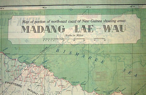
In September 1943, AAF requested that the Army Map Service prepare the first cloth map of the Southwest Pacific Area series. This was map Nos. 27/28 of northeastern coast of New Guinea with a scale of 1:500,000.[88] The base map was compiled from maps prepared by the Australian Land Headquarters and information provided by the Allied Geographic Section of the Southwest Pacific Area (SWPA) Command. The New Guinea map, like all maps in this series, was printed with different geographic areas on both sides. For example, sheet number No. 28 from Wewak south to Mandang was printed on one side and the reverse side includes sheet No. 27 showing the area from Mandang south to Salamaua. The Nos. 27/28 New Guinea map was the only cloth map produced whose primary color was green and as such does not resemble the other maps subsequently produced.
AAF Nos. 27 / 28 This map was printed on balloon cloth while most of the other AAF cloth maps were printed on acetate rayon. Interesting features on the map include the location of emergency landing airstrips and notes regarding the size of boats that can navigate some of the rivers. The maps, printed by the Kaumagraph Company were delivered to the ACS Washington Region Store located at 1222 22nd Street N.W., Washington, D.C. in November 1943.[89] In December 1943, MIS-X SWPA distributed these maps primarily to the bomber and fighter commands of the 5th US Air Force for use on the northeastern coast of New Guinea.[90] The New Guinea map is fairly scarce as only 3,000 copies were printed.[91] This shipment was followed up in April and May 1944[92] with the rest of the maps in the Southwest Pacific Area Series, which had been requested by MIS-X through AAF in September 1943 also.[93] These maps, with a scale of 1:1,000,000, were complied from Australian Aeronautical Charts, Dutch Aeronautical Charts, British Admiralty Charts, Netherland Hydro Charts, US Hydrographic Office Charts, Netherland New Guinea Petroleum Company maps, and earlier editions of Army Map Service maps, all supplemented by intelligence data gathered in theater. The cloth maps include the usual typographic features along with offshore information about shoals, reefs and rocks. The maps contain some elevation data but do not include contour lines. The maps were complied in the Mercator projection, and compilation and drafting of each map cost approximately $1,500 and reproduction cost approximately 60 cents per map.[94] When the latter maps arrived, all were desperately needed in the SWPA theater, except for Nos. 16/17 of the Owen Stanley Mountains of New Guinea on one side and New Britain the other side. The areas covered by Nos. 16/17 were under Allied control or had been bypassed and the enemy isolated by the time the maps arrived in theater, although 1,000 copies of those maps were sent by MIS-X SWPA to Aircraft, Northern Solomons (AirNorSols) in July 1944 at its request.[95] AirNorSols consisted predominantly of Marine aviation units and was assigned in Summer 1944 to the SWPA's Far East Air Forces. At that time, AirNorSols? primary targets were Bougainville, Rabul on New Britain, and Kavieng on New Ireland.
Southwest Pacific Series Because the Southwest Pacific Area Series was not available earlier, MIS-X SWPA arranged for the map section of the Royal Australian Air Force (RAAF) to print substitute silk maps for use until the AAF maps arrived, although the RAAF maps were not considered a totally satisfactory substitute because they lacked the detail of the AAF maps. Nonetheless, the RAAF maps were the described as the best available substitute.[96] Additional production runs of the Southwest Pacific Area Series maps were made, [97] except for Nos. 16/17 and Nos. 27/28, which had only one printing of 8,000[98] and 3,000[99] copies respectively. The maps of the Southwest Pacific Area Series were not issued to just US and RAAF air crews, but were also used by PT boat squadrons and other rescue units operating in the Southwest Pacific.[100] 2. Mediterranean Series The cloth maps used by Allied forces in the European theater were produced by the British, except for the AAF Mediterranean Series. In August 1943 AAF requested that the Army Map Service prepare the following six map sheets in this series for MIS-X.[101]
However, three weeks later, AAF cancelled the request for Nos. 1, 2, 3 and 5.[102] The following charts were printed instead:
Nos. 4/6 was printed on balloon cloth by the Kaumagraph Company in December 1943 in a quantity of 8,525 copies[103] and shipped at the request of MIS-X to the Assistant Chief of Staff for Intelligence, Allied Forces Headquarters in March 1944.[104] This map has a scale of 1:2,000,000 and was produced in the Lambert conformal conic projection. It includes rough elevation tick marks.
Mediterranean Series In April 1944, AAF requested preparation of an addition cloth map of Mediterranean France and Lyons Torino.[105] These map sheets were produced from the British GSGS 4072 paper series at a scale of 1:500,000 in the modified polyconic projection. The Nos. 7/8 map includes elevation tints with contour lines. The Kaumagraph Company printed and delivered 2,000 copies of this cloth map to the Army Map Service in June 1944.[106] There was only one printing of this map; thus map Nos. 7/8 is relatively scarce. These escape maps were issued to the Mediterranean Allied Air Forces. In August 1943, AAF requested that the Army Map Service prepare a six-sheet Asiatic Series as follows.[107]
The Asiatic Series cloth maps were all in the Lambert conic projection with a scale of 1:2,000,000. They contain normal typographic features along with some rough elevation tick marks. There were numerous reprints of the Asiatic Series map until the conclusion of the war,[108] and they were issued primarily to US and British units operating in the China, India, Southwest Pacific, and Central Pacific theaters.[109] Some of the later printings contain ocean wind and surface currents directional arrows and data. The need for silk maps of China was emphasized in a letter from MIS-X China to Lt. Col. Johnson of MIS-X Washington in November 1943 advising the maps produced in India [presumably by the Survey of India] were inadequate because the scale of 1:4,000,000 was useless for the needs of his theater. The letter recommended that a scale of 1:2,000,000 was required. MIS-X China also recommended that additional maps be produced of the Yellow Sea, Eastern Sea and adjacent land areas, North China and all of Korea. Finally, it suggested it would be extremely helpful if place names were in both English and Chinese on the maps.[110] In February 1944, Major Winfrey, MIS-X Washington, responded and informed MIS-X China that the Asiatic series had been produced and would be completed by the end of February 1944.
Asiatic Series Major Winfrey also stated that pursuant to a letter from MIS-X China, dated January 3, 1944, MIS-X Washington was considering the production of four cloth maps of East China at a scale of 1:1,000,000 million and portions of the Japanese Islands at a scale of 1:4,000,000, both with Chinese and Roman characters, as recommended by MIS-X China. Major Winfrey recommended that such maps of China could be made from existing AAF aeronautical charts at a scale of 1:1,000,000. However, the maps available with both Chinese and Roman characters were currently a series of Army Map Service maps at a scale of 1:300,000. However, if these maps were reduced to a scale of 1:1,000,000, the amount of detail contained on them would make the maps practically illegible. He also mentioned consideration was being given to producing a series of large scale silk cloth maps of possible target areas in Eastern China at a scale of 1:300,000 and invited MIS-X China?s recommendations.[111] During 1944, MIS-X China suggested consideration of a new set of large scale maps printed on waterproof paper and bound in book form to replace the Asiatic Series cloth maps. The idea was dismissed by Washington because the sheer size of the book would be untenable. As was explained in a letter to MIS-X China, to produce such maps at a scale of 1:250,000 would require a book with 192 sheets slightly larger than 18 x 24 inches. If the page size were reduced to 5 x 8 inches it would require 2075 pages to replace the 3 cloth maps in the Asiatic Series.[112] In a historical report of MIS-X China prepared shortly after WW II, the unidentified author indicates that of all the escape and evasion items provided by MIS-X Washington, the cloth map was the principal item pilots liked, as it gave flight crews a chance to orient themselves if they went down. The author concludes, however, that because most downed airmen in China made contact with friendly natives within a few hours, the maps did not actually aid in evasions as a rule.[113] Three cloth maps were produced in the Philippine Series.
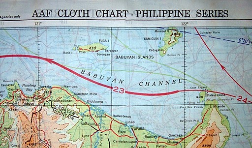
The first map of the series contains the island of Luzon on one side and map sheet No. 34 (Southeast China) of the Asiatic Series on its reverse side. This is explained in a May 8, 1944 letter from MIS-X Washington to MIS-X China, in which Colonel Catesby ap C. Jones explained that due to a new order for C-34 without C-35 which originally appeared on the reverse side, a change was made to the arrangement of the new Philippine Series with the first chart in the Series being No. 34/C-40.[114] Nonetheless, requests from MIS-X detachments in the China, India, Pacific Ocean Area and SWPA theaters for cloth map C-34/C-35 continued until the conclusion of the war and numerous reprintings were made.[115] In fact, C-34/C-35 was the second most printed chart during the war, with over 230,000 copies ordered from the printers.[116]
Philippine Series AAF submitted its request for the Philippine Series maps in September 1944, and the first maps were printed in the fall of 1944.[117] Additional printings of the maps were made.[118] All of the maps of the Philippine Series were in the Lambert conformal conic projection with a scale of 1:1,000,000. All contain elevation tints, although C-41/C-42 was also printed for the Navy without the elevation tints. Later versions of the maps include ocean wind and surface current directional arrows and data. As would be expected, most of these maps were issued by MIS-X SWPA to US and RAAF units operating in the Southwest Pacific theater.[119] The Eastern Asia Series consisted of the following cloth maps encompassing eastern China and Japan labeled with the numbering system based on the International Maps of the World (IMW) numbering system.
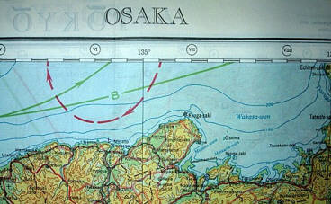
NI 52 / NI 53 The series began in early 1944 with cloth maps of Kagoshima, Nagasaki, Osaka and Tokyo, followed several months later with the rest of the maps in the series. The maps all contain a scale of 1:1,000,000 in the modified polyconic projection of the IMW The maps of Japan were drawn from Japanese Imperial Land Survey Maps dated 1933, with data revised based on intelligence reports. Chinese and Japanese place names were corrected to modified Hepburn (Romaji system). All of the maps included elevation tints, although maps without elevation tints were made specifically for the US Navy of all of the maps in this series except NL50/NL51. Several reprints were made of the maps through the rest of the war.[120] Because the war ended without an invasion of Japan, many of these maps were never issued to operational forces even though a large number of maps were printed.[121] 6. Miscellaneous AAF Escape Maps The following miscellaneous cloth escape maps were made for the AAF during World War II.
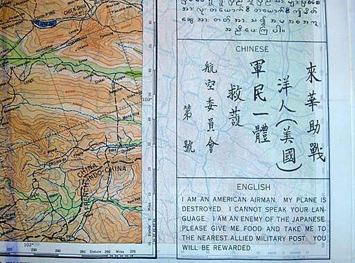
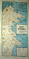
a. Map C-36 Map C-36 depicts central east Asia and the other side (C-37) was intended to be a detailed map of Korea. C-36 is at a scale of 1:5,000,000 in the Lambert conformal conic projection, and contains elevation tints for lower elevations. It was the largest cloth map produced during WWII and covers Eastern China, Korea, the China Sea and Japan. The wind and current data depicted on this map was taken from the Navy NACI-HO S-12 Western Pacific Ocean handkerchief chart.[122] AAF requested preparation of C-36/C-37 in July 1944,[123] and at the end of July 1945 the Army Map Service contracted with the Kaumagraph Company to print the maps. However, due to the Japanese surrender the order was cancelled on August 20, 1945. The contractor had, nonetheless, already printed C-36 on one side of the cloth maps and was directed to cease work and to deliver the charts as printed. Thus, the charts delivered were only printed on one side.[124] b. Maps C-45/C-46 & C-47/C-48 Maps C-45/C-46 and C- 47/C-48 depict Borneo and Java in the Dutch East Indies. C-47/C-48 shows south Borneo and west Java. It was requested by AAF in July 1944, and the first printing was completed in August 1944. [125] C-45/C-46, which contains east and west Borneo, was requested by AAF in September 1944.[126] There were reprintings of both maps.[127] The maps are in the Mercator projection and have a scale of 1:1,000,000. c. Map C-50/C-51 Map C-50/C-51 shows British and French Guiana and northeastern Brazil. This cloth map was requested in January 1944 by the Caribbean Wing of the Air Transport Command headquartered in West Palm Beach, Florida. The request to ACS for the map explained that the "[t]he new AAF cloth maps have aroused a great deal of interest in this Headquarters" and a cloth map containing the area between British Guiana and Natal, Brazil, on the South American route of the Air Transport Command would be of great advantage to aircrews who might be forced down in those jungle areas.[128] In April 1944, the AAF requested these maps be complied and drafted by the Army Map Service at a cost of $2,000.00;[129] which the Army Map Service completed in May 1944. These maps do not appear to have been intended for use as an aid for escaping or evading enemy personnel. Rather, they were intended for use by aircrews of the Air Transport Command, which ferried aircraft through Central and South America, across the Atlantic Ocean to west Africa, and then on to other theaters. One can presume their use was for general survival navigation purposes in the event the aircraft were downed in those regions. The maps have a scale of 1:2,000.000 and are based on the Mercator projection. d. Map C-52/C-53 The escape map is at a scale of 1:4,000,000 and covers the east coast of Asia from French-Indo-China to latitude 54 degrees North, the Kuriles, Japan, Formosa, Luzon, and Marianas Islands, the South China Seas and the East China Sea. The British GSGS map 2957 was the source material for the cloth maps. Preparation of C-52/C-53 was requested by MIS-X POA and was intended to replace many of the existing cloth charts covering those areas.[130] As such, the maps were intended for general use during the expected invasion of Japan. However, because of its scale of 1:4 million, the map actually did not serve as a substitute for more detailed cloth maps and accordingly printing of the detailed cloth maps was continued throughout the war. Over 406,000 copies of C-52/C-53 were ordered, making it the most printed US cloth escape map during the war.[131] All of these maps were printed during the last six months of the war and MIS-X records show that only 143,950 maps were shipped to Pacific and Southwest Pacific theaters.[132] e. Map No. 133 Map No. 133 was printed at the request of MIS-X China and it covered the area from Kunming, China to Chabua , India, and was intended to meet the requirements of pilots flying over the Hump in the China-Burma-India (CBI) theater. It was designated No. 133 because it was based on an existing paper strip map known as Flight Chart No. 133, which had previously been prepared by the U.S. Coast and Geodetic Survey. [133] Preparation of the base map cost approximately $200 in 1944, not including printing costs.[134] The AAF Aeronautical Chart Service determined which portions of Flight Chart No. 133 were to appear on the cloth map. The US Coast and Geodetic Survey then prepared the base map for the cloth map at the request of the Army Map Service. The map possesses a scale of 1:1,000,000 in the Lambert conformal conic projection. The map contains elevation tints and thus is mostly of a brownish tint due to the high elevations along the Hump, with elevations exceeding 23,000 feet. At the request of MIS-X, the map also included a blood chit. This is the only cloth map that had a blood chit printed on it. The blood chit contains the following message in Bengali, Hindustani (Urda), Kachin, Lisu, Burmese, and Chinese. I AM AN AMERICAN AIRMAN. MY PLANE IS DESTROYED. I CANNOT SPEAK YOUR LANGUAGE. I AM AN ENEMY OF THE JAPANESE. PLEASE GIVE ME FOOD AND TAKE ME TO THE NEAREST ALLIED MILITARY POST. YOU WILL BE REWARDED.
Blood Chit on No. 133
f. Map C-384/C-385 Map C-384/C-495 was printed at the request of MIS-X India.[135] These map sheets are copies of AAF Aeronautical Charts of the same numbers[136] covering the geographical area of Chungking, China, north of the area of central China covered by C-33, although there is a slight overlap with the northern part of C-33. The map was produced in the Lambert conformal conic projection at a scale of 1:1,000,000 with elevation tints. g. Maps C-859/C-860 & C-800/C-920 C-859/C-860 and C-800/C-920 were prepared at the request of MIS-X Washington even though no theater initially requested production of the maps. These cloth maps like C-384/C-394 are copies of AAF Aeronautical Charts of the same numbers and slightly overlap southern parts of C-30 and C-32 and cover the remainder of the Malay Peninsula and the northern half of Sumatra.[137] The maps were shipped to MIS-X SWPA.[138] Also, the Army Map Service procured 10,000 copies of each map without tints for the Navy.[139] All of the cloth maps were produced in the last few months of the war, [140] and therefore it is questionable how many were actually issued to operating units. The maps are at a scale of 1:1,000,000 and in the Mercator projection. In July 1945, the Army Map Service began preparing another escape cloth map. On one side was to be C-62 of the Pacific Ocean islands and the other side was to be C-63 of the Atlantic Ocean islands. The composite charts were prepared, but were never printed on cloth.[141] Included in the WWII records of the US Navy Intelligence's Air Intelligence Group, is a list of cloth maps and charts produced during WWII by the AAF and Navy. Two additional purported cloth maps are listed. [142]
The areas covered by these purported maps include Sumatra and Java. Nonetheless, the wartime production records of the Army Map Service do not contain any indication that such cloth maps were printed. The nomenclature of these maps suggests they correspond to the AAF Aeronautical Charts of the same numbers. It is doubtful that these charts were produced as cloth maps, especially in light of the fact that the latter chart is already covered by escape map C-48. One can assume that these charts were erroneously listed as cloth charts. Finally, postwar records of HQ AAF contain an inventory of cloth maps in HQ AAF's possession immediately after the war. The list includes a cloth map of England and Ireland, although records of the Army Map Service do list such a cloth map. [143] Perhaps it was a British map or some secret Army Map Service produced map. A large number of unissued maps were left over at the conclusion of the war as evidenced by the large number of cloth maps on sale to the public by the War Assets Administration in the years following the war.[144] Post-war records of HQ AAF indicate that AAF had 216,189 cloth maps in its inventory shortly after the war.[145]
F. Navy NACI-HO Survival Cloth Charts In October 1943, a conference was held with representatives of the AAF Aeronautical Chart Service (ACS), MIS-X, and the Navy Air Technical Analysis Division of the US Navy Air Intelligence Group to coordinate the production of cloth maps being prepared by AAF and the Navy. At the meeting, coordinates of the cloth maps being prepared by the AAF were checked with the proposed cloth charts of the Navy to prevent any overlap or duplication of coverage. To the credit of all persons involved in the meeting, it was agreed that before any additional cloth maps were planned, an exchange of information would be coordinated to prevent duplication of effort.[146] ACS also recommended to the Navy: It is felt that the value of the [US Navy] charts would be enhanced by drafting the islands on a large scale and showing their relative position on a small insert map. This could be accomplished by showing on one side of the cloth the area as indicated on the layout and on the other side detailed drawings of the principal islands.[147] The suggestion was not accepted by the Navy. The following charts were prepared through the collaboration of the US Navy Hydrographic Office (Op-28) and the Air Intelligence Group of the Division of Naval Intelligence (Op-16-V).
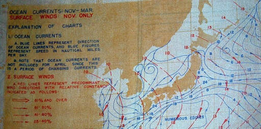
The Navy handkerchief charts, so called because of their size of 15 3/4 x 12 3/4 (except for the larger S-12 chart) resembled a handkerchief, were designed primarily for use by Navy and Marine pilots operating from carriers or island bases and were intended for use in the event of a forced sea landing and as an aid in the navigation of rubber life rafts. The background color of the charts is white, with cultural features in black and land masses in green, and do not include the more elaborate elevation tints common on many AAF maps, although they do include rough elevation contours lines. At the October 1943 conference, the Navy representative agreed to also include the inland cultural features on the charts for the benefit of the Thirteenth Air Force, which also operated in the areas covered by the charts. [148] The charts are all made on the standard Mercator projection and were printed on rayon acetate. To expedite their initial distribution, a minimum quantity (1,300 copies each) of the first six, double-sided charts were distributed to aviation units of the Pacific Fleet in the winter of 1944 without current and wind data because the data was not available in the form required at that time. [149] The first six charts issued were: (1) S12-20&16 / S12-9&26, (2) S12-11 / S12-8, (3) S12-1&25 / S12-23&25, (4) S12-19 / S12-2, (5) S12-14 / S12-2, and (6) S12-21 / S12-29&22. In March 1944, Navy Air Combat Intelligence requested that the US Navy Hydrographic Office prepare ocean current streamlines showing current velocity, direction and steadiness for two seasons and at a scale to conform to the previously produced NACI-HO cloth charts for inclusion on subsequent reprintings. The winter stream drifts were sent to Op-16-V on April 11, 1944, and the summer data followed later. Navy Air Combat Intelligence also requested that the US Navy Hydrographic Office prepare a brief manual explaining how to use the charts so intelligence officers could briefings pilots accordingly.[150] Prior to January 1945, each chart contained either summer or winter ocean current data; however, after that date the charts were printed with both summer and winter data. [151] The ocean current data was supplied by the US Navy Hydrographic Office.
NACI-HO Map Corners The one Navy cloth chart not of handkerchief size, S-12, is an extremely large chart of the entire western Pacific Ocean area with a trim size of approximately 36" x 27 1/2". Both sides of the chart depict the same geographic area, although one side contains winter ocean and wind currents while the reverse side contains summer currents. Finally, there is a separate black and white instruction sheet (OPNAV-16-V #S109) that was also printed on acetate rayon and accompanied the cloth charts. This instruction sheet contains detailed information explaining how to navigate a raft using the data on the charts. The charts were intended for each by: (1) men on rafts to estimate their drift and to help in choosing a course and (2) by officers directing air-sea rescue operations to help in choosing the search area and the method of search.[152] The introduction to the detailed instruction states: WHAT THE CHARTS SHOW The streamline on the handkerchief charts show the average current near the surface. The arrows on the streamlines indicate the average direction of flow, and the numbers indicate the average speed of the current in nautical miles per day. The heaviness of the streamlines shows the steadiness of the current, that is, the percentage of the time that the current actually flows in the average direction. The heavier and more solid the line, the more you can rely on the current which it shows. The shaded arrows on the charts give the average wind direction for each area. The numbers on the arrows show the average Beaufort force of the wind. The direction and speed of the current will vary somewhat with wind force and direction. When the wind has been blowing for several hours, with the direction and force indicated by the arrow nearest your position, the current will flow about as shown on the chart. If the wind has been blowing in a different direction or at a different speed, the actual current will be a combination of that shown on the chart with the current set up by the wind. Currents near shore will usually differ in speed and direction from those prevailing offshore. Such currents nearly always flow parallel to the beach and are mainly due to the tide, that is, they fluctuate in speed and often reverse direction every 6 or 12 hours.[153] The instruction sheet goes on to provide very detailed instructions on plotting courses based on the information on the charts and explains that the charts are not accurate during the months of October and March when the seasons are changing except in limited geographic areas where the currents do not vary much between the summer and winter seasons. Some of the charts were ordered from the commercial printer by the Army Map Service to meet requirements of MIS-X, AAF and the Navy,[154] while other copies of the maps were ordered by the Navy directly from the printers. All of the charts were printed by the Kaumagraph Company, while both Kaumagraph and the Sweeney Lithograph Company printed copies of the instructional sheet.[155] Copies of the charts met an enthusiastic reception from British naval personnel at Colombo, Ceylon, who remarked in a letter to the US Navy Hydrographic Office that similar charts would satisfy an unmet need of RAF sea and rescue units and could be adapted by them to the Bay of Bengal, their big area of interest. The letter expressed uncertainty as to "whether there will be sufficient weight brought to bear upon some organization to prepare the drift charts on the pattern of yours for the Bay of Bengal is something we don?t know as yet." [156] The author has not found any record that suggests such charts were produced.
G. RAAF Silk Escape Maps Produced for MIS-X Because the shipments of the AAF Southwest Pacific series escape maps produced by the Army Map Service were not received in a timely fashion in the Southwest Pacific Area (SWPA) theater, MIS-X SWPA made arrangements in early 1944 with the Cartographic Section of the Royal Australian Air Force (RAAF) to produce silk maps of New Guinea, Halmahera, Celebes, Banda Sea, and Borneo and agreed to replace the silk used with US map cloth.[157] MIS-X records reflect that 10,000 square feet of blank map cloth was shipped by MIS-X Washington in January 1944 to SWPA and was received in May 1944,[158]and an additional 7,162 yards of map cloth and 35,000 yards of rejected parachute silk were shipped by MIS-X Washington to MIS-X SWPA for use in the production of these locally obtained maps.[159] In October 1944, MIS-X SWPA received RAAF silk maps of the Philippine Islands at the same time that the AAF Philippine series arrived.[160] Apparently, RAAF produced the Philippine maps not wanting to rely on the timely arrival of the AAF maps. The silk maps were basic outline maps, and although the RAAF maps were not considered a totally satisfactory substitute because they lacked the detail of the AAF maps, the RAAF maps were described as the best available substitute at the time.[161] MIS-X SWPA records indicate that the following silk maps were obtained from the RAAF.[162]
The author has seen at least two more RAAF silk map that cover the Darwin and the Pine Creek areas of Australia, although it has been reported that additional silk maps exist. The maps covering the New Guinea and the Dutch East Indies are black and white with brown elevation tints, while the later Philippine maps also use blue for water bodies. The silk maps were produced in a variety of scales from Australian L.H.Q. paper maps and include many inserts of land masses. This was necessary because the combined area covered by the silk maps extends from New Guinea to Luzon and includes most islands in between. It is reported that Australian pilots wore the maps as scarves around their necks.[163]
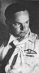
RAAF pilot wearing cloth map RAAF East Borneo silk map Two other one-sided silk charts depicting the SWPA theater of operations were produced by the Cartographic Section of the RAAF in October 1944 at the request of MIS-X SWPA. [164] The charts look identical but contain wind and ocean current data for different months of the year. One charts depicts ocean currents for May through September and surface winds in knots with separate inserts for each of the months from May through October. The other chart contains like ocean current information for November through March and surface winds for November through April. Ocean currents for April and October are not shown because the seasons change during those months and thus the currents are not stable. The data for the charts was complied by the 2nd and 3rd Operations Analysis Section of Headquarters, Far East Air Force from ocean current charts designed by the Scripps Institute of Oceanography and wind charts prepared by the US Weather Bureau. The charts are distinctive because the land masses are depicted by a dull orange color. MIS-X SWPA records indicate that over 8,000 copies of the former chart were produced and over 21,000 copies of the later were produced.[165] (Click here to view the maps.)
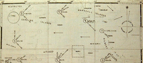
FEAF Ocean Current and Surface Winds Map H. Conclusion The maps described above were the primary cloth maps made by the US during the World War II. Nonetheless, local units occasionally prepared cloth maps earlier in the war prior to the production of the AAF cloth maps and the NACI-HO cloth charts. One example is a cloth map of the Gilbert and Carolina Islands. It was accompanied by two sets of survival notes also prepared on cloth, one specifically with advice and native language for servicemen downed in the Gilberts. The notes state that winds are westerly, which is prevalent from May through October, thus this map may have been used in the months leading up to the invasions of Tarawa and Makin in November 1943, or thereafter. The accompanying survival notes reference the surf at Nanakuli, a beach located on the west shore of Oahu, suggesting the map might have been prepared for Navy and Marine pilots, although the Seventh Air Force operated in the Central Pacific area during that time frame as well. (Click here to see Gilbert and Carolina Islands survival map and notes.)
Gilbert and Carolina Islands Survival Map Lloyd Shoemaker, a member of MIS-X Washington during WWII, recounts in his book The Escape Factory that the Playing Card Company of Cincinnati, Ohio, printed silk maps that were cut into paying card size pieces and glued between the front and back pieces of the playing cards. The cards were then smuggled into German POW camps as contents of relief society parcels. Shoemaker states that 50 different maps were sent by MI 9 to MIS-X and the company printed some on silk for the cards. From Shoemaker's description of the four-color maps and their size of 18" x 28", it is apparent these were Bartholomew maps.[166] The actual extent to which cloth maps issued during WW II contributed to the safe return of military personnel probably will never be known. Nonetheless, a report from MI 9's E Group in India stated, "We have been told that at least one man in Wingate?s Brigade [Chindits] got out of Burma thanks entirely to this silk map (and his guts!)."[167] As one person involved with MIS-X during World War II stated, If it [MIS-X activities] had contributed nothing more than a few isolated rescues it still would have been a worthwhile program. When a nation requires its men to face death in the air daily in its protection, it also has a definite responsibility toward making every effort to safeguard their lives against needless sacrifice. Many a pilot is, today, a living testimony to the fact that Uncle Sam did not forget his airborne nephews.[168] Those military personnel who were rescued, and those who fortunately never found themselves in such predicament, but who gained some comfort from knowing they were equipped with escape maps, owe a debt of gratitude to the men and women who toiled behind the scenes at the Army Map Service, Aeronautical Chart Service, D Survey, other government mapping organizations that assisted in compiling and drafting the maps, and the commercial contractors who diligently performed the tiresome and laborious printing of over three and one-half million cloth escape maps during WWII, and finally to MIS-X and MI 9 that requested and distributed the maps. The story of the cloth escape maps is just one of countless examples of the citizens of the Allied nations engaging in extraordinary efforts to safeguard the lives of their fighting men from needless sacrifice during WWII. [46] Memorandum to Commanding Officer, Army Map Service, from Lt. Colonel E.R. Swanson, Chief, Map-Chart Division, Headquarters, Army Air Force, October 26, 1942, Subject: Compilation and Reproduction of Maps; AMS Production Order No. 23939 (1942). [47] Memorandum to Chief, Map-Chart Division, Headquarters Army Air Force, from Lt. Colonel Fredrick W. Mast, Executive Officer, Army Map Service, November 26, 1942, Subject: Cloth Maps. [48] Appendix I, Report on Cloth Maps for Army Air Forces, Memorandum Report prepared by Lt. Col. James G. Strobridge (Army Map Service), Subject: Cloth Maps, May 21, 1943. [49] AMS Production Order No. 24226 (1942). [50] Appendix I, Report on Cloth Maps for Army Air Forces, Memorandum Report prepared by Lt. Col. James G. Strobridge (Army Map Service), Subject: Cloth Maps, May 21, 1943. [51] Army Map Service Memo of Telephone Conversation, March 10, 1943. [52] Appendix I, Report on Cloth Maps for Army Air Forces, Memorandum Report prepared by Lt. Col. James G. Strobridge (Army Map Service), Subject: Cloth Maps, May 21, 1943. Calendered is a process by which paper of cloth is pressed between rollers to give the material a smooth finish. [53] Army Map Service Routing Slip, April 22, 1943; Memo from Lt. Col. James G. Strobridge (AMS) to Col. Mast (AMS), Subject: Cloth Maps, May 4, 1943. [54] Letter from W.L. O'Donovan (Celenes Corp.) to Col. F.W. Nast [sic] (Army Map Service), Subject: Celanese Cloth for Map Printing, April 15, 1943. [55] Letter from W.O. O'Donovan (Celanese Corp.) to Lt. Col. F.W. Mast (Army Map Service), April 19, 1943. Service [56] Letter from William L. O'Donovan (Celanese Corp.) to Lt. Col. F.W. Mast (Army Map Service), May 6, 1943. [57] Letter from Lt. Col. James G. Strobridge (Army Map Service) to Mr. Thomas H. Miller (Kaumagraph Co.), May 7, 1943. [58] Letter from T.H. Miller (Kaumagraph Co.) to Lt. Col. James G. Strobridge (Army Map Service), May 14, 1943. [59] Letter from National Bureau of Standards to Capt. M.H. Bruno (Army Map Service), Subject: Cloth Maps, April 15, 1943. [60] Memo from Col. Russell H. Sweet (MIS-X) to Lt. Col. A.R. Wichtrich (MIS-X AGAS-China), Subject: Permanency of Blood Chits, 18 July 1945 . [61] Army Map Service Routing Slip, April 22, 1943. [62] Letter from Assistant General Manager (Fuchs & Lang Manufacturing Co.) to Lt. Col. James G. Strobridge (Army Map Service), April 30, 1943. [63] Appendix I, Report on Cloth Maps for Army Air Forces, Memorandum Report prepared by Lt. Col. James G. Strobridge (Army Map Service), Subject: Cloth Maps, May 21, 1943. [64] Exhibit VI to Report on Cloth Maps for Army Air Forces, Memorandum Report prepared by Lt. Col. James G. Strobridge (Army Map Service), Subject: Cloth Maps, May 21, 1943. [65] Appendix I, Report on Cloth Maps for Army Air Forces, Memorandum Report prepared by Lt. Col. James G. Strobridge (Army Map Service), Subject: Cloth Maps, May 21, 1943. [66] Appendix I, Report on Cloth Maps for Army Air Forces, Memorandum Report prepared by Lt. Col. James G. Strobridge (Army Map Service), Subject: Cloth Maps, May 21, 1943. [67] Appendix I, Report on Cloth Maps for Army Air Forces, Memorandum Report prepared by Lt. Col. James G. Strobridge (Army Map Service), Subject: Cloth Maps, May 21, 1943. [68] Appendix I, Report on Cloth Maps for Army Air Forces, Memorandum Report prepared by Lt. Col. James G. Strobridge (Army Map Service), Subject: Cloth Maps, May 21, 1943. [69] MIS-X Status of Requests for Equipment 1 June 45 (S); Memo from Col. Russell H. Sweet (MIS-X) to S/Ldr. C. Whitehead (MI 9), Subject: Stiffed Cloth for Cloth Charts, 23 July 45. [70] Appendix I, Report on Phosphorescent Cloth Maps for the Army Air Forces, Memorandum Report prepared by Lt. Col. James G. Strobridge (Army Map Service), Subject: Cloth Maps (Phosphorescent), July 15, 1943. [71] National Bureau of Standards Report on Test of Phosphorescent Map, May 28, 1943. [72] Report on Phosphorescent Cloth Maps for the Army Air Forces, Memorandum Report prepared by Lt. Col. James G. Strobridge (Army Map Service), Subject: Cloth Maps (Phosphorescent), July 15, 1943. [73] Memorandum to The Hydrographer from Lt. (j.g.) David Luria, War Production Board, Allentown, Pennsylvania, September 28, 1942, Subject: Luminous non-destructible cloth maps. [74] For a detailed discussion of the development of fluorescent charts, see Alfred H. Burton, Conquerors of the Airways: A Brief History of the USAF-ACIC and Aeronautical Charts, publication of the USAF Aeronautical Chart and Information Center, June 1953, pp.128-54. The 1942 records of the US Hydrographic Office also indicate that office was also exploring the use of fluoresce for chart making, Letter from Rear Admiral G.S Bryan, Navy Hydrographer to Rear Admiral T.S. Wilkinson, USN, October 15, 1942. [75] Memorandum to Chief, Military Intelligence Division, Prisoner of War Branch, from Lt. Colonel F.R. Cochran, Executive, Aeronautical Chart Service, May 20, 1994, Subject: AAF Cloth Charts. [76] Memorandum to Commanding Officer, Army Map Service, from Lt. Colonel F.R. Cochran, Executive, Aeronautical Chart Service, January 10, 1944, Subject: Corrected Final Composite Proofs; Memorandum to Commanding Officer, Army Map Service, from Lt. Colonel F.R. Cochran, Executive, Aeronautical Chart Service, January 13, 1944, Subject: Corrected Final Composite Proof; Memorandum to Commanding Officer, Army Map Service, from Lt. Colonel F.R. Cochran, Executive, Aeronautical Chart Service, January 15, 1944, Subject: Corrected Final Composite Proof; Memorandum to Commanding Officer, Army Map Service, from Lt. Colonel F.R. Cochran, Executive, Aeronautical Chart Service, January 18, 1944, Subject: Corrected Final Composite Proof; Memorandum to Commanding Officer, Army Map Service, from Lt. Colonel F.R. Cochran, Executive, Aeronautical Chart Service, January 19, 1944, Subject: Corrected Final Composite Proof; Memorandum to Commanding Officer, Army Map Service, from Lt. Colonel F.R. Cochran, Executive, Aeronautical Chart Service, January 21, 1944, Subject: Final Composite Proofs; Memorandum to Commanding Officer, Army Map Service, from Lt. Colonel F.R. Cochran, Executive, Aeronautical Chart Service, January 25, 1944, Subject: Corrected Final Composite Proofs; Memorandum to Commanding Officer, Army Map Service, from Lt. Colonel F.R. Cochran, Executive, Aeronautical Chart Service, January 26, 1944, Subject: Final Composite Proofs; Memorandum to Commanding Officer, Army Map Service, from Lt. Colonel F.R. Cochran, Executive, Aeronautical Chart Service, January 27, 1944, Subject: Final Composite Proof; Memorandum to Commanding Officer, Army Map Service, from Lt. Colonel F.R. Cochran, Executive, Aeronautical Chart Service, May 3, 1944, Subject: Final Composite Proof. [77] Memorandum to District Engineer, Army Map Service, Lake Survey District, Attention: Major M.R. Edwards, from Captain L.C. Benedict, Executive Officer, Aeronautical Chart Service, October 14, 1943, Subject: Cloth Maps. [78] Alfred H. Burton, Conquerors of the Airways: A Brief History of the USAF-ACIC and Aeronautical Charts, publication of the USAF Aeronautical Chart and Information Center, June 1953, p. 159. [79] Alfred H. Burton, Conquerors of the Airways: A Brief History of the USAF-ACIC and Aeronautical Charts, publication of the USAF Aeronautical Chart and Information Center, June 1953, pp. 157-58. [80] ACS Weekly Report (18 Oct 43 – 23 Oct 43) from Capt. L.C. Benedict (ACS) to Historical Officer, October 25, 1943 (Confidential). [81] ACS Weekly Report (18 Oct 43 – 23 Oct 43) from Capt. L.C. Benedict (ACS) to Historical Officer, October 25, 1943 (Confidential). [82] Memorandum from Lieut. Cdr. Hugh Breckenridge, Navy Air Intelligence Group Op-16-V-S to Air Navigation Division, Navy Hydrographic Office Op-28, October 16, 1944, Subject: Winter and Summer Currents. [83] Memorandum from Lieut. Cdr. Hugh Breckenridge, Navy Air Intelligence Group Op-16-V-S to Air Navigation Division, Navy Hydrographic Office Op-28, August 25,1944, Subject: Cloth Survival Charts Published by the MIS. Memorandum to Lt. Comdr. Brechinridge, Naval Intelligence, Op-16-VS, from B.E. Dodson (By direction of the Hydrographer), Subject: Current information; submittal of (Restricted). [84] Memorandum to Major A.R. Wichtrich, MIS-X China from Colonel Russell H. Sweet, MIS-X Washington, August 14, 1944, Subject: Estimated Future Needs of Cloth Maps. [85] Memorandum to MIS-X POA from Colonel Russell H. Sweet, MIS-X Washington, February 1, 1945, Subject: Status of Requests for Equipment (Secret). [86] Memorandum to Lt. Col. Gerald Fitzgerald, ACS from Colonel Russell H. Sweet, MIS-X Washington, August 10, 1944, Subject: Estimated Future Needs of Cloth Maps. [87] Albert A. Stanley, "Cloth Maps and Charts," The Military Engineer, March 1947, Vol. XXXIX, No. 257, p 126. [88] AMS Production Order No. 28515 (1943). [89] AMS Production Order No. 28535 (1943). [90] Monthly Report for December 1943, Briefing Activities MIS-X, SWPA, December 31, 1943. [91] AMS Production Order No. 28515 (1943). [92] AMS Production Order No. 28532 (1943). Letter to Col. J.E. Johnston, MIS-X Washington from Capt. H.A. Rosenquist, MIS-X SWPA, April 24, 1944 (Secret); Monthly Report for April 1944 to Chief, MIS-X Washington from Headquarters, Allied Air Forces, May 5, 1944, Subject: Monthly Report, MIS-X Activities, SWPA (Secret); Monthly Report for May 1944 to Chief, MIS-X Washington from Headquarters, Allied Air Forces, June 14, 1944, Subject: Monthly Report, MIS-X Activities, SWPA (Secret). [93] Memorandum to Commanding Officer, Army Map Service, from Lt. Col. Gerald Fitzgerald, Chief, Aeronautical Chart Service, October 6, 1943, Subject: Cloth Maps for Members of Air Crews, Southwest Pacific Area (Secret). [94] Memorandum to Commanding Officer, Army Map Service, from Lt. Col. Gerald Fitzgerald, Chief, Aeronautical Chart Service, October 6, 1943, Subject: Cloth Maps for Members of Air Crews, Southwest Pacific Area (Secret). [95] Monthly Report for April 1944 , MIS-X Activities, SWPA, July 5, 1944; Monthly Report for July 1944 , MIS-X Activities, SWPA, August 12, 1944; . [96] Report of MIS-X Section SWPA, February 1944; Monthly Report for May 1944 to Chief, MIS-X Washington from Headquarters, Allied Air Forces, June 14, 1944, Subject: Monthly Report, MIS-X Activities, SWPA (S).. [97] AMS Production Order No. 31338 (1944); AMS Production Order No. 32242 (1944); AMS Production Order No. 3-2609 (1944). [98] AMS Production Order No. 28532 (1943). [99] AMS Production Order No. 28515 (1943). [100] Memorandum for Fleet Intelligence Officer and Chief of Section MIS-X from Lt.(j.g.) Thomas Rogers Drake, Navy Liaison Officer, MIS-X SWPA, April 24, 1944; MIS-X Technical Section War Diary for August and September 1945, prepared by Major Leo H. Crosson, October 5, 1945 (Secret). [101] Memorandum to Commanding Officer, Army Map Service, from Lt. Col. Gerald Fitzgerald, Chief, Aeronautical Chart Service, August 5, 1943, Subject: Cloth Maps for Members of Air Crews (Confidential). [102] AMS Production Order No. 28104 (1943). [103] AMS Production Order No. 28956 (1943). [104] Memorandum to Military Intelligence Division, Prisoner of War Branch, March 27, 1944, Subject: Shipment of Cloth Maps (Restricted). [105] AMS Production Order No. 30846 (1944). [106] AMS Production Order No. 31245 (1944). [107] Memorandum to Commanding Officer, Army Map Service, from Lieut. Col. Gerald Fitzgerald, Chief, Aeronautical Chart Service, August 12, 1943, Subject: Cloth Maps for Members of Air Crews, Asiatic Series, Scale 1:2,000,000 (Confidential); AMS Production Order No. 28105 (1943). [108] AMS Production Order No. 31640 (1944); AMS Production Order No. 3-2610 (1944); AMS Production Order No. 3-4323 (1944); AMS Production Order No. 3-6249 (1945); AMS Production Order No. 3-7145 (1945). [109] MIS-X Technical Section War Diary for August and September 1945, prepared by Major Leo H. Crosson, October 5, 1945 (Secret). [110] Letter from Lt B.P. Schoyer to Lt. Col. J.E. Johnson, November 10, 1943 (Secret). [111] Memorandum for Major A.R. Wichtrich, MIS-X China from Major Robley E. Winfrey MIS-X, February 24, 1994 (Secret). [112] Memorandum to Major A.R. Wichtrich, MIS-X China, from Colonel Russell H. Sweet, MIS-X Washington, July 29 1944, Subject: Small Size Evasion Maps (Secret). [113] Air Ground Aid Section (MIS-X China) A Brief History and Analysis, undated, at 38 (Confidential). [114] Memorandum to Major P.S. Kraus, MIS-X SWPA from Colonel Catesby ap C. Jones, MIS-X Washington, May 8, 1946, Subject: Information on Shipment, Charts, and Proposed Radio Equipment (Secret). [115] AMS Production Order No. 3-2609 (1944); AMS Production Order No. 3-2610 (1944); AMS Production Order No. 3-423 (1945); AMS Production Order No. 3-6249 (1945); AMS Production Order No. 3-7145 (1945); Memorandum to MIS-X POA from Colonel Russell H. Sweet, MIS-X Washington to MIS-X POA, May 1, 1945, SUBJECT: Status of Request for Equipment, (Secret). [116] AMS Production Order No. 28105 (1943); AMS Production Order No. 3-2609 (1944); AMS Production Order No. 3-2610 (1944); AMS Production Order No. 3-4323 (1944); AMS Production Order No. 3-6249 (1945); AMS Production Order No. 3-7145 (1945). [117] AMS Production Order No. 3-2865 (1944). [118] AMS Production Order No. 3-4323 (1944) [119] MIS-X Technical Section War Diary for August and September 1945, prepared by Major Leo H. Crosson, October 5, 1945 (Secret). [120] AMS Production Order No. 30241 (1944); AMS Production Order No. 31211 (1944); AMS Production Order No. 32609 (1944); AMS Production Order No. 3-2610 (1944); AMS Production Order No. 3-4323 (1944). [121] Final Report of MIS-X, POA: November 8, 1944 to September 25, 1945(S); General Headquarters United States Army Forces, Pacific, MIS-X Section Monthly Report June 1945, July 7, 1945 (Secret). [122] AMS Production Order No. 3-6839 (1945). [123] AMS Production Order No. 32008 (1944). [124] MIS-X Technical Section War Diary for July 1945, prepared by Major Leo H. Crosson, August 10, 1945 (Secret); AMS Production Order No. 3-7070 (1945). [125] AMS Production Order No. 32067 (1944). [126] AMS Production Order No. 3-2865 (1944). [127] AMS Production Order No. 3-2609 (1944); AMS Production Order No. 3-2610 (1944); AMS Production Order No. 3-4323 (1944). [128] Memorandum to Aeronautical Chart Service, Attention: Major D.F. Jamieson, from Captain Harold M. Morgan, Actg. Asst. Adj. Gen., Headquarters Caribbean Wing, January 21, 1944, Subject: Request for Cloth Charts (C). [129] Memorandum to Commanding Officer, Army Map Service, from Lt. Colonel Gerald Fitzgerald, Chief, Aeronautical Chart Service, April 6, 1944, Subject: AAF Cloth Charts, Scale 1:2,000,000. [130] Memorandum to MIS-X POA from Colonel Russell H. Sweet, MIS-X Washington, February 1, 1945, Subject: Status of Requests for Equipment (Secret); Memorandum to Lt. Col. Wichtrich, MIS-X China from Colonel Russell H. Sweet, MIS-X Washington, April 24 1945, Subject: Cloth Charts (Confidential). [131] AMS Production Order No. 3-5096 (1945); AMS Production Order No. 3-6142 (1945); AMS Production Order No. 3-6231 (1945); AMS Production Order No. 3-6381 (1945); AMS Production Order No. 3-7145 (1945). [132] MIS-X Technical Section War Diary for August and September 1945, prepared by Major Leo H. Crosson, October 5, 1945 (Secret). [133] Memorandum for Major A.R. Wichtrich, MIS-X China from Major Robley E. Winfrey MIS-X, February 24, 1994 (Secret). [134] Memorandum to Commanding Officer, Army Map Service, from Lt. Colonel Gerald Fitzgerald, Chief, Aeronautical Chart Service, March 6, 1944, Subject: AAF Cloth Map No. 133. [135] Memorandum to Lt. Col. Wichtrich, MIS-X China from Colonel Russell H. Sweet, MIS-X Washington, April 24 1945, Subject: Cloth Charts (Confidential). [136] Memorandum to MIS-X POA from Colonel Russell H. Sweet, MIS-X Washington, December 1, 1944, Subject: Status of Requests for Equipment (Secret). [137] Memorandum to MIS-X POA from Colonel Russell H. Sweet, MIS-X Washington, March 1, 1945, Subject: Status of Requests for Equipment (Secret). [138] MIS-X Technical Section War Diary for August and September 1945, prepared by Major Leo H. Crosson, October 5, 1945 (Secret). [139] AMS Production Order No. 3-6381 (1945). [140] AMS Production Order No. 3-5881 (1945); AMS Production Order No. 3-6381 (1945). [141] AMS Production Order No. 3-6851 (1945). [142] Index continued in WWII records of the Navy Intelligence, Air Intelligence Group, undated. [143] Undated AAF Cloth Map Inventory, post-war. [144] Albert A. Stanley, "Cloth Maps and Charts," The Military Engineer, March 1947, Vol. XXXIX, No. 257, p 126. [145] Undated AAF Cloth Map Inventory, post-war. [146] ACS Weekly Report (18 Oct 43 ? 23 Oct 43) from Capt. L.C. Benedict (ACS) to Historical Officer, October 25, 1943 (Confidential). [147] Memorandum to Deputy Chief of Naval Operations for Air (Op.-35) from Lieut. Col. Gerald Fitzgerald, Chief, Aeronautic Chart Service, October 27, 1943, Subject: Cloth Maps. [148] ACS Weekly Report (18 Oct 43 ? 23 Oct 43) from Capt. L.C. Benedict (ACS) to Historical Officer, October 25, 1943 (Confidential). [149] Memorandum from Ward Cheney (By direction) Chief of Naval Operations to Commander Air Force Pacific, et. al., February 7, 1944, Subject: Waterproof Charts. [150] Memorandum to the Navy Hydrographer from G.T. Mundorff, Jr. (By Direction), March 3, 19444, Subject: Preparation of Charts of Ocean Streamlines- Request fro (Confidential). [151] Memorandum to MIS-X POA from Colonel Russell H. Sweet, MIS-X Washington, January 1, 1945, Subject: Status of Requests for Equipment (Secret). [152] The Use of Cloth Survival Charts in the Navigation of Rubber Rafts, OPNAV-16-V #S109, Air Intelligence Group, Division of Naval Intelligence, prepared by the Hydrographic Office, July 1944. [153] The Use of Cloth Survival Charts in the Navigation of Rubber Rafts, OPNAV-16-V #S109, Air Intelligence Group, Division of Naval Intelligence, prepared by the Hydrographic Office, July 1944. [154] AMS Production Order No. 3-2876 (1944); AMS Production Order No. 3-3980 (1944); AMS Production Order No. 3-4323 (1944); AMS Production Order No. 3-4330 (1944). [155] AMS Production Order No. 3-3673 (1944); AMS Production Order No. 3-4323 (1944); AMS Production Order No. 3-7130 (1945). [156] Letter to Lt. Mary Sears, Oceanographic Unit, US Navy Hydrographic Office, from Captain Charles C. Bates, Swell Section, Joint Meteorological Center, Colombo, Ceylon, April 17, 1945, Subject: Discussion of Oceanographic Problems (Confidential). [157] Report of MIS-X Section SWPA, February 1944. [158] Memorandum to Major Paul S. Kraus, MIS-X SWPA from Colonel Catesby ap C. Jones, MIS-X Washington, April 8, 1944, Subject: Shipment of Evasion Aids (Secret); Monthly Report for May 1944 to Chief, MIS-X Washington from Headquarters, Allied Air Forces, June 14, 1944, Subject: Monthly Report, MIS-X Activities, SWPA (Secret). [159] MIS-X Technical Section War Diary for August and September 1945, prepared by Major Leo H. Crosson, October 5, 1945 (Secret). [160] Monthly Report for October 1944 to Chief, MIS-X Washington from Headquarters, Allied Air Forces, November 21, 1944, Subject: Monthly Report, MIS-X Activities, SWPA (Secret). [161] Report of MIS-X Section SWPA, February 1944; Monthly Report for May 1944 to Chief, MIS-X Washington from Headquarters, Allied Air Forces, June 14, 1944, Subject: Monthly Report, MIS-X Activities, SWPA (Secret). [162] MIS-X [SWPA] Section Monthly Report for June 1945, General Headquarters United States Army Forces, Pacific, July 7, 1945 (Secret). [163] "Cloth Charts Bring Survivors Back," Air Sea Rescue Bulletin, Vol. II, No. 1, September 1945, pp. 2-7. [164] Monthly Report for October 1944 to Chief, MIS-X Washington from Headquarters, Allied Air Forces, November 21, 1944, Subject: Monthly Report, MIS-X Activities, SWPA (Secret). [165] MIS-X [SWPA] Section Monthly Report for June 1945, General Headquarters United States Army Forces, Pacific, July 7, 1945 (Secret). [166] Lloyd R. Shoemaker, The Escape Factory, St. Martin's Press, New York 1990, pp. 108-111. [167] Memorandum from Lt. W.R.P. Ridgeway, GSI9E) India to Brigadier N.R. Crockatt, MI 9, June 25, 1943, Subject: Progress Report No. 6 (Most Secret). [168] "Underground Railway," written for publication in O.N.I. Review, February 1946 (author unknown). |
||||||||||||||||||||||||||||||||||||||||||||||||||||||||||||||||||||||||||||||||||||||||||||||||||||||||||||||||||||||||||||||||||||||||||||||||||||||||||||||||||||||||||||||||||||||||||||||||||||||||||||||||||||||||||||||||||||||||||||||||||||||||||
|
|
||||||||||||||||||||||||||||||||||||||||||||||||||||||||||||||||||||||||||||||||||||||||||||||||||||||||||||||||||||||||||||||||||||||||||||||||||||||||||||||||||||||||||||||||||||||||||||||||||||||||||||||||||||||||||||||||||||||||||||||||||||||||||
|
© Copyright 2008. All rights reserved. |
||||||||||||||||||||||||||||||||||||||||||||||||||||||||||||||||||||||||||||||||||||||||||||||||||||||||||||||||||||||||||||||||||||||||||||||||||||||||||||||||||||||||||||||||||||||||||||||||||||||||||||||||||||||||||||||||||||||||||||||||||||||||||